
الرسوم المتحركة لطبقات الأرض.
بحث جديد بقيادة جامعة كامبريدج هو أول بحث يحصل على “صورة” مفصلة لجيب غير عادي من الصخور في الطبقة الحدودية مع قلب الأرض ، على بعد حوالي ثلاثة آلاف كيلومتر تحت السطح.
المنطقة الغامضة من الصخور ، والتي تقع مباشرة تقريبًا أسفل جزر هاواي ، هي واحدة من عدة مناطق ذات سرعة منخفضة للغاية – يطلق عليها لأن موجات الزلزال تتباطأ إلى الزحف أثناء مرورها عبرها.
البحث المنشور في المجلة بتاريخ 19 مايو 2022 اتصالات الطبيعة، هو أول من يكشف عن التباين الداخلي المعقد لأحد هذه الجيوب بالتفصيل ، مما يلقي الضوء على المناظر الطبيعية للأرض الداخلية العميقة والعمليات التي تعمل داخلها.
“من بين جميع السمات الداخلية العميقة للأرض ، هذه هي الأكثر روعة وتعقيدًا.” – زي لي
“من بين جميع السمات الداخلية العميقة للأرض ، هذه هي الأكثر روعة وتعقيدًا. قال المؤلف الرئيسي Zhi Li ، طالب الدكتوراه في قسم علوم الأرض في كامبريدج ، “لقد حصلنا الآن على أول دليل قوي لإظهار هيكلها الداخلي – إنه معلم حقيقي في علم الزلازل في أعماق الأرض”.
يتكون الجزء الداخلي من الأرض مثل البصل: في المركز يوجد قلب الحديد والنيكل ، وتحيط به طبقة سميكة تعرف باسم الوشاح ، وفوق ذلك قشرة خارجية رقيقة – القشرة التي نعيش عليها. على الرغم من أن الوشاح عبارة عن صخرة صلبة ، إلا أنه ساخن بدرجة كافية بحيث يتدفق ببطء شديد. تقوم التيارات الحرارية الداخلية بتغذية الحرارة إلى السطح ، مما يؤدي إلى حركة الصفائح التكتونية وتغذية الانفجارات البركانية.
يستخدم العلماء الموجات الزلزالية من الزلازل “لرؤية” ما تحت سطح الأرض – تكشف أصداء وظلال هذه الموجات صورًا شبيهة بالرادار للتضاريس الداخلية العميقة. ولكن حتى وقت قريب ، كانت “صور” الهياكل الموجودة على حدود اللب-الوشاح ، وهي منطقة ذات أهمية رئيسية لدراسة تدفق الحرارة الداخلي لكوكبنا ، محببة ويصعب تفسيرها.
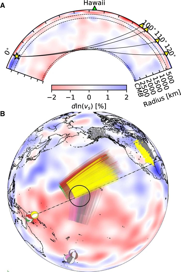
الأحداث ومسارات أشعة Sdiff المستخدمة في هذه الدراسة. أ) مقطع عرضي يقطع مركز منطقة السرعة المنخفضة للغاية في هاواي ، ويظهر مسارات أشعة لموجات Sdiff عند 96 درجة و 100 درجة و 110 درجة و 120 درجة لنموذج الأرض 1D PREM. تشير الخطوط المتقطعة من أعلى إلى أسفل إلى الانقطاع البالغ 410 كم و 660 كم و 2791 كم (100 كم فوق حدود اللب والوشاح). ب) الأحداث ومسارات أشعة Sdiff على نموذج التصوير المقطعي للخلفية SEMUCB_WM1 على عمق 2791 كم. كرات الشاطئ للأحداث المرسومة بألوان مختلفة منها 20100320 (أصفر) ، 20111214 (أخضر) ، 20120417 (أحمر) ، 20180910 (بنفسجي) ، 20180518 (بني) ، 20181030 (وردي) ، 20161122 (رمادي) ، محطات (مثلثات) ، وشعاع. مسارات موجات Sdiff على عمق ثقب 2791 كم في الوشاح السفلي المستخدم في هذه الدراسة. يتم تمييز الحدث المستخدم في تحليل الفترة القصيرة باللون الأصفر. يظهر موقع ULVZ المقترح في دائرة سوداء. يُظهر الخط المتقطع المقطع العرضي المرسوم في A. Credit: Nature Communications، DOI: 10.1038 / s41467-022-30502-5
استخدم الباحثون أحدث طرق النمذجة العددية للكشف عن هياكل بمقياس كيلومتر عند حدود الوشاح الأساسي. وفقًا للمؤلف المشارك الدكتور Kuangdai Leng ، الذي طور الأساليب أثناء وجوده في[{” attribute=””>University of Oxford, “We are really pushing the limits of modern high-performance computing for elastodynamic simulations, taking advantage of wave symmetries unnoticed or unused before.” Leng, who is currently based at the Science and Technology Facilities Council, says that this means they can improve the resolution of the images by an order of magnitude compared to previous work.
The researchers observed a 40% reduction in the speed of seismic waves traveling at the base of the ultra-low velocity zone beneath Hawaii. This supports existing proposals that the zone contains much more iron than the surrounding rocks – meaning it is denser and more sluggish. “It’s possible that this iron-rich material is a remnant of ancient rocks from Earth’s early history or even that iron might be leaking from the core by an unknown means,” said project lead Dr Sanne Cottaar from Cambridge Earth Sciences.

Conceptual cartoons of the Hawaiian ultra-low velocity zone (ULVZ) structure. A) ULVZ on the core–mantle boundary at the base of the Hawaiian plume (height is not to scale). B) a zoom in of the modeled ULVZ structure, showing interpreted trapped postcursor waves (note that the waves analyzed have horizontal displacement). Credit: Nature Communications, DOI: 10.1038/s41467-022-30502-5
The research could also help scientists understand what sits beneath and gives rise to volcanic chains like the Hawaiian Islands. Scientists have started to notice a correlation between the location of the descriptively-named hotspot volcanoes, which include Hawaii and Iceland, and the ultra-low velocity zones at the base of the mantle. The origin of hotspot volcanoes has been debated, but the most popular theory suggests that plume-like structures bring hot mantle material all the way from the core-mantle boundary to the surface.
With images of the ultra-low velocity zone beneath Hawaii now in hand, the team can also gather rare physical evidence from what is likely the root of the plume feeding Hawaii. Their observation of dense, iron-rich rock beneath Hawaii would support surface observations. “Basalts erupting from Hawaii have anomalous isotope signatures which could either point to either an early-Earth origin or core leaking, it means some of this dense material piled up at the base must be dragged to the surface,” said Cottaar.
More of the core-mantle boundary now needs to be imaged to understand if all surface hotspots have a pocket of dense material at the base. Where and how the core-mantle boundary can be targeted does depend on where earthquakes occur, and where seismometers are installed to record the waves.
The team’s observations add to a growing body of evidence that Earth’s deep interior is just as variable as its surface. “These low-velocity zones are one of the most intricate features we see at extreme depths – if we expand our search, we are likely to see ever-increasing levels of complexity, both structural and chemical, at the core-mantle boundary,” said Li.
They now plan to apply their techniques to enhance the resolution of imaging of other pockets at the core-mantle boundary, as well as mapping new zones. Eventually, they hope to map the geological landscape across the core-mantle boundary and understand its relationship with the dynamics and evolutionary history of our planet.
Reference: “Kilometer-scale structure on the core–mantle boundary near Hawaii” by Zhi Li, Kuangdai Leng, Jennifer Jenkins and Sanne Cottaar, 19 May 2022, Nature Communications.
DOI: 10.1038/s41467-022-30502-5

ليان القحطاني كاتبة في موقع alqraralaraby.news، تكتب في مجالات الأخبار والسياسة والأعمال والتكنولوجيا والرياضة والترفيه وأسلوب الحياة. تركّز على تقديم تغطية واضحة وموثوقة للمستجدات، وتوفير معلومات مفيدة للقرّاء، مع الاهتمام بالقصص والموضوعات ذات الصلة بالحياة اليومية والأحداث الراهنة بأسلوب مهني وسهل المتابعة.


قصص أخرى
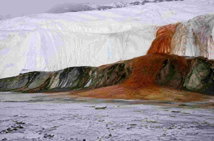
شلالات الدم في القارة القطبية الجنوبية.. ظاهرة طبيعية تكشف أسرار عالم معزول منذ 1.5 مليون عام
ماذا ينتظر الأرض بعد موت الشمس؟ اكتشاف فلكي غير مسبوق يقرّب العلماء من الإجابة
صاروخ فالكون 9 التابع لشركة سبيس إكس يتوقف قبل إطلاقه ملياردير في مهمة خاصة